If you can find a Delaware Bay nautical chart from years ago, you may be able to discover the location of the Overfalls Lightship (about 3 miles due east of Cape Henlopen). This detail of a section of a 1957 chart shows that location. If you look closely at the image printed on the chart though, there is actually a lot more information than just the location of the ship.
Here is how to decipher all of the lightstation information shown on the chart:
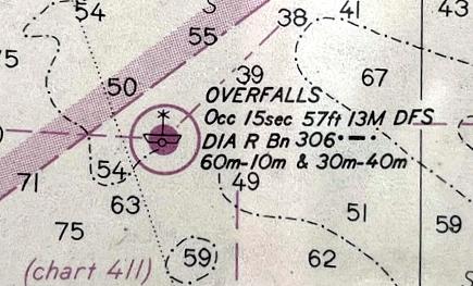
• OVERFALLS – The ship’s name is printed in big block letters on her hull.
• Occ 15sec – This means she had an “occulting” light. This is not a flashing light, but one that would have an on/off cycle of 15 seconds.
• 57ft 13M – The light on top of the mast was 57 feet above the waterline and was visible from 13 miles away.
• DFS – Overfalls was a “Distance Finding Station.” Her radio beacon was broadcast to coordinate with her foghorn. This gave ships a way to calculate a bearing and their distance from her.
• DIA R Bn 306 ●▬● – She had a diaphone style foghorn and a radio beacon that broadcast a dot dash dot pattern on 306Khz.
• 60m-10m & 30m-40m – The radio beacon was broadcast on this schedule (on the hour and at 10, 30 and 40 minutes after the hour) giving shipping the ability to coordinate their radio watches.
Probably WAY more than you wanted to know…